touch
Eastern Türkiye
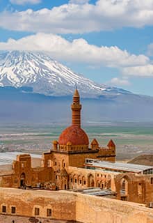
Mount Ararat (Ağrı Dağı) in Ağrı
Mount Ararat (Ağrı Dağı), the highest point (at 5,137 m) of both Türkiye and Europe, can be seen from vast distances across the eastern Turkish plain, rising ethereally into the clouds. In 2004, it was declared a national park. Its summit, snow-capped all year, is a dormant volcanic cone covered with glaciers, the largest permanent ice-mass in Türkiye.
It consists of two major volcanic cones: Greater Ağrı and Little Ağrı. Greater Ağrı is the highest peak in Türkiye with an elevation of 5,137 m; Little Ağrı's elevation is 3,896 m. The Ağrı massif is about 35 km wide at ground base.
The mount is mentioned in sacred texts, in the context of the story of Noah’s Ark, makes this massif special. Claimed to be “impossible to climb” by the famous explorer Marco Polo, for many years this majestic mountain haunted the dreams of adrenalin-addicted explorers.
The first recorded efforts to reach Ararat's summit were made in the Middle Ages, and Friedrich Parrot, Khachatur Abovian, and four others made the first recorded ascent in 1829.
The mountain has been called by the name Ağrı (Ararat) in the west since the Middle Ages, as scholars took it be the "mountains of Ararat" described in the Bible in Genesis 8:4. Although the citation does not refer to a single mountain the hypothesis was that the passage must refer to here as it is the highest point in the region and that, therefore, it is the resting place of Noah's Ark.
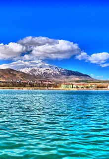
Lake Van in Van and Bitlis
In the Eastern Anatolia Region of Türkiye, Lake Van (Van Gölü) is situated between Bitlis and Van provinces. It is a lake formed by a volcanic eruption. As a result of the explosion of Mount Nemrut, Lake Van was formed when the waters filled up over time.
Four islands are located to the lake's east: Adır, Akdamar, Kuş, and Çarpanak. The islands, which attract tourists with their historical features, were declared an archaeological site in 1990.
Lake Van has the distinction of being the largest saline soda (alkaline) lake in Türkiye and the largest soda lake on Earth. It has limited biodiversity due to the nature of its water. The only fish species that live in the lake is the pearl mullet (Alburnus tarichi).
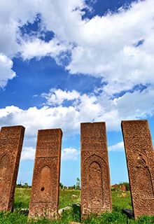
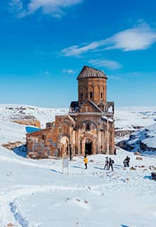
The fortress was also cult center for the god Haldi, the warrior god in Urartian culture. Today, Urartu temples, altar stairs and tombs of kings, Persian inscriptions, and Ottoman mosques are found at Van Fortress, just west of west of Van and east of Lake Van.
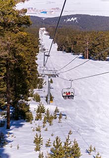
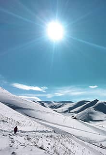
Palandöken Ski Center in Erzurum
Erzurum, the largest city in Eastern Anatolia, is sprawled over a high plateau at an altitude of 1,950 meters. A road running through splendid mountain scenery leads to the winter sports resort of Palandöken, just six km from Erzurum city center. It has a number of hotels as well as the longest ski run and the high snow quality, thus making it a favourite haunt for expert skiers.
It is one of the closest ski resorts to an airport; just a five-minute drive after your plane lands and you can be out on the snow of Palandöken's slopes. Palandöken offers many opportunities to lovers of winter sports and is coated in fine snow that first falls in November and settles till June. Fog, a great danger for skiers, does not descend there. The weather is clear, the slopes are the longest in Türkiye and skiing fanatics can marvel at the stunning landscape. It is also an ideal place to forget about stress and pressures of daily life.
Karanlık Canyon (Dark Canyon) in Erzincan
Karanlık Canyon literally "Dark Canyon", is a deep steep-sided gorge located in Kemaliye district of Erzincan. The canyon is formed by Karasu River on the Munzur Mountains.
The canyon is 25 km long, 1,000 m deep and 10 - 15 m wide at the base featuring almost 90% rocky slope gradient.
The canyon offers outdoor recreational activities such as rock climbing and boat rides.
Saklıkapı Canyon in Elazığ
Saklıkapı Canyon (Saklıkapı Kanyonu), which begins at the shores of the Karakaya Dam Lake and runs along the 2,5 km long line between the districts of Baskil and Keban in Elazığ, is a canyon that was discovered by pure chance.
In recent years, the canyon has drawn attention with its height that ranges between 20 and 200 meters, the karstic topography, and the large variety of plants. Karaleylek Canyon is near Saklıkapı Canyon and features steep cliffs, karstic cave formations, and historical cave settlements.
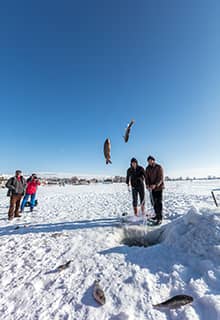
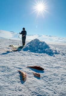
Lake Çıldır in Ardahan
Located 44 kilometers from the Ardahan city center, Lake Çıldır (Çıldır Gölü) attracts attention both in summer and winter.
Lake Çıldır is at an altitude of 1959 meters above sea level and covers 123 square kilometers. The area of Lake Çıldır contains a restaurant, few short and flat trails, and the lake itself.
Lake Çıldır is almost totally covered by ice in the winter months. It usually starts to freeze at the beginning of winter as the temperature drops to minus 10°C during the nights. The lake stays frozen about eight months of the year.
When the lake is frozen, it is possible to horse, to ride a bike and to walk on ice. You can also watch local fishermen fishing by breaking the ice and enjoy fresh fish in a few restaurants around the lake.
Lake Nemrut in Bitlis
Lake Nemrut (Nemrut Gölü) is located on the summit of Mount Nemrut at an altitude of 2,800 meters. It is in the district of Tatvan in Bitlis. Lake Nemrut has the distinction of being the second-largest crater lake in the world and the largest in Türkiye. It is a freshwater lake and has a surface area of 15 square kilometers. A bird's-eye view of this lake, which has a depth of 176 meters, shows that it is crescent-shaped. The lake also has an area suitable for camping.
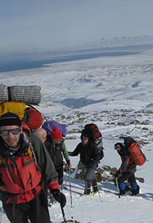
Mount Cilo in Hakkari
Mount Cilo (Cilo Dağı) with an altitude of 4,135, located in the Yüksekova district of Hakkari, is the second-highest mountain in Türkiye. It is a tectonic mountain whose summit is permanently covered with snow and ice and forms the easternmost extension of the south eastern Taurus Mountains.
The Uludoruk Glacier is a glacier on Mount Uludoruk located in the immediate vicinity (4 km) of Mount Cilo and also part of the Taurus Mountains.
Prehistoric rock paintings depicting reverse tulips, people, snakes, deer, mountain goats, wild sheep, rabbits, wolves, foxes, and symbolic shapes have been found in the area near the summit of Mount Cilo and attract the attention of visitors.
Munzur Mountains in Tunceli
The Munzur Mountains (Munzur Dağları) (3,000 m) are located in the Ovacık district of Tunceli.
The mountains offer visitors’ the cultural assets, a deep history, and the natural beauty. The melting snow forms glacial lakes surrounded in lush green plateaus. This eye-catching beauty attracts nature lovers from the surrounding province and districts who come here to appreciate the wonders of nature.
Visitors start their journey at Kırkmerdiven Valley and following steep and snowy trails reach the highlands and glacial lakes. From there, the highlands of Teng, Sor, Gani Hesen, Kormuskan, Korteres and Kepir are accessible.
Mount Süphan in Ağrı, Bitlis and Muş
Mount Süphan (Süphan Dağı) is the 3rd tallest mountain in Türkiye, and is located of the districts of Malazgirt, Patnos, and Ahlat. It is a composite volcano which has a conical shape built up by many layers of hardened lava.
Mount Süphan is immediately north of Lake Van. This mountain is located in the vicinity of Adilcevaz and Patnos. To climb Mount Süphan, an activity best undertaken in summer, a permission must be obtained from the authorities of Adilcevaz. At the summit, there is a mound about a kilometer long formed by lava.